


Roof inspections via drone are becoming common practice around Australia as insurance companies realise the benefits of faster, more accurate and especially safer assessments.
We provide aerial roof inspections to many of Western Australia’s insurance companies, via AirAssess.
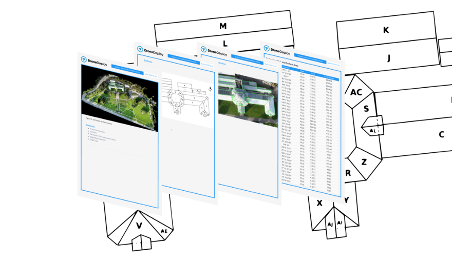
Our high-resolution UAV cameras provide detailed photos of all aspects of the roof as well as an overall orthographic 3D map, allowing accurate measurement.
Drone Inspections Improve the Accuracy and Consistency of Rooftop Measurements
From twisted tape measures to inconsistent endpoint selection, to inaccessible edges, it’s difficult to maintain accuracy and consistency within a set of rooftop measurements.
But where human ability falls short, machine learning now picks up the slack. Solutions like Roof Report use the latest advances in drone mapping technology to take accurate measurements of square footage, roof features, pitch, surface area, and slope in a matter of minutes. And rigorous tests have shown these measurements to be consistently 99.4% accurate.
No more worrying about inaccurate data or having to return to a site to gather missed information. The solution uses a set protocol for selecting endpoints, so measurements are complete and consistent throughout an entire project.
Drones are a Safer, Cost-Effective Alternative to Boots-on-the-Roof
Falls are the leading cause of death on industrial job sites. With drones, you reduce, and in some cases eliminate, the need for ladder assists and boots-on-the-roof data collection.
The Beck Group — a Dallas-based commercial architecture and construction company — uses drones to perform remote roof inspections and cut the amount of time employees spend in dangerous areas. As Grant Hagen points out, if he can reduce time spent on a roof by three hours, that’s three hours an employee is on the ground and out of harm’s way.
“Any time you can limit putting your staff in a dangerous situation, it’s a win.” — Grant Hagen, VDC Manager at the Beck Group.
Drone Technology Delivers a Rich Dataset and Powerful Return-on-Investment
Drones are a far faster and more cost-effective way to gather information and turn it into actionable data. In fact, end-to-end drone solutions have proven to be at least three times faster than traditional methods.
But the return-on-investment for drones on rooftops goes beyond just the savings in time and human resources. Drones deliver a far more productive set of data compared to what can be gathered by manual measurement.
Drone mapping doesn’t just deliver data on roof planes, slopes, and areas. A detailed point cloud captures the entirety of the roof in high-resolution detail, giving a powerful set of data to residential and commercial roofers, solar installers, and anyone looking to do design work on top of drone-based roof data. And all of this data is readily shareable in a variety of export formats so that you can integrate it with your favorite industry tools.
Roof Report From DroneDeploy is an End-to-End Solution for Roofing, Insurance, and Solar
Roof Report from DroneDeploy is a drone-based inspection and measurement solutions. Professionals in industries like roofing, insurance, and solar can now use a single tool to collect drone imagery and generate accurate roof measurements and reports in a matter of hours.
“We’ve been working closely with some of the largest solar and insurance companies in North America to bring our customers a reliable and accurate drone roofing solution,” says Mike Winn, CEO of DroneDeploy.
Benefits of Roof Report From DroneDeploy
- Automate the collection of high-resolution roof imagery
- Generate accurate roof reports with the click of a button
- Take consistent, accurate measurements of square footage, roof features, pitch, surface area, and slope
- Access a PDF file for easy sharing and collaboration
- Export a roof geometry DXF file compatible with your existing tools for CAD analysis and design
- 3X faster than traditional methods
- Collect data in a consistent, repeatable way
Where to Learn More
For an overview of the new Roof Report from DroneDeploy, as well as best flight practices for capturing roof imagery, be sure to read the product announcement.
